The Aftermath of the Eaton Fire: Home Sales in the Affected Area
A wave of heavily damaged and destroyed homes has come onto the market, selling for half of 2024 prices, and likely below pre-fire bare land values
As California’s fire season re-ignites, with the Madre fire burning in the San Louis Obispo area, Los Angeles County is still assessing the damage and consequences of the devastating January wildfires.
A key concern is the effect on impacted homeowners, and on the wealth they had invested in their homes. In principle, fire and homeowner insurance should help cover the costs of displacement and reconstruction. The crucial problem, however, is that private insurers had stopped renewing fire insurance policies in the areas that were later hit by the fires. While local homeowners could have switched to the California FAIR Plan, a state-backed insurance option, many may have chosen to remain uninsured. This is especially true for homeowners who had fully paid off their mortgages and were therefore not required by lenders to obtain new insurance. Even those who did obtain a new policy may have underinsured their homes, selecting policy coverages well below market values to reduce premium costs.
Homeowners who are now unable to obtain insurance payouts or financial aid may be forced to sell their damaged homes, because they cannot afford the rebuilding costs and are likely under financial pressure from having to pay for temporary housing while they are displaced. Selling a damaged home in the immediate aftermath of a disaster is likely to result in a low sales price and a large capital loss, even after accounting for avoided rebuilding expenses. This is because few buyers are willing to invest in a severely damaged property, or in a disaster area.
We take an initial look at key patterns in home sales before and after the Eaton Fire in Altadena. To understand how housing market trends in the fire-affected area diverge from those in nearby unaffected areas, we compare listings within the fire perimeter to those in surrounding neighborhoods located within a 2.5-mile buffer zone outside the perimeter.
We find a sharp increase in sales volume within the fire-affected area, with many properties sold as “lots.” Nearly all of these sales involve heavily damaged homes, whether listed as single-family residences or vacant lots. Single-family listings are selling for roughly half the price relative to homes sold in the same area in 2024, and relative to 2025 sales in neighboring, unaffected areas. These post-fire sales prices likely fall below pre-fire bare land values. Lot sales prices also appear to fall below pre-fire land values.
Volume and Characteristics of Sold Properties
Our analysis combines data from three sources: home and lot sales scraped from Zillow for the period between January 1st 2024 and June 18th 2025, parcel-level shapefiles for Los Angeles County, and fire damage information published by CAL FIRE.1
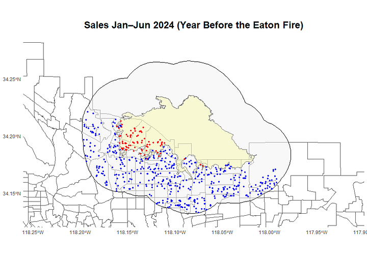
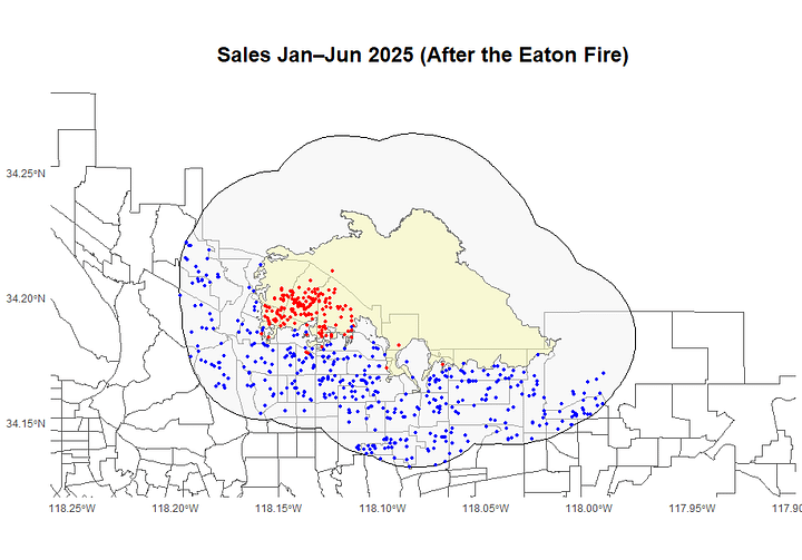
The maps below visualize changes in sales volume in the area struck by the Eaton fire (in yellow), relative to the nearby neighborhoods (in grey), located within a 2.5-mile buffer of the fire boundaries. The map on the left displays the locations of all sales that occurred between January 2024 and June 2024. Red dots represent sales that occurred in the area later affected by the Eaton fire in January 2025. The blue dots represent sales in the surrounding area. The second map presents the same analysis for the period from January 2025 to June 2025, after the fire struck.
It is clear that, in the aftermath of the Eaton Fire, sales volume within the fire perimeter is significantly higher than during the same months in the previous year.


To explore this pattern further, the graphs below display the total number of monthly home sales from January 2024 to June 2025 in both the Eaton Fire area and the surrounding neighborhoods within a 2.5-mile radius of the fire perimeter. They also distinguish between properties sold as “lots” and those sold as single-family homes. While sales volume increases after the fire both within and outside the fire perimeter, the rise is far more dramatic within the fire-stricken zone. In 2024, monthly sales in the fire area ranged between 9 and 20. That number jumps to 35 in March 2025 and to 60 in April.
Moreover, lot sales were virtually nonexistent in both the fire-affected area and the surrounding neighborhoods prior to January 2025. After the fire, they remain highly uncommon in the surrounding areas but increase sharply within the affected zone. They account for approximately 50% of all sales in most months, and nearly all sales in June.
Intuitively, these lots represent properties that were completely destroyed by the fire. However, even the single-family home sales in the Eaton Fire area almost exclusively involve heavily damaged structures. In the table below, we match the 174 properties sold between January and June 2025 with fire damage data provided by CAL FIRE. Nearly all of these properties sustained damage to 50% or more of their structure.
Property Prices
At what prices are the fire-impacted properties selling? The figure below shows the median sales price per square foot for single-family listings, each month from January 2024 to June 2025. In 2024, median prices are similar in both the Eaton Fire area and the surrounding neighborhoods, averaging around $800 per square foot. In 2025, prices in the surrounding areas remain stable, while prices in the fire-affected area drop sharply, and range from $200 to $400 per square foot.
While this decline is consistent with the fact that most of the properties sold in the fire zone are heavily damaged, the magnitude of the drop is particularly striking. A recent research paper estimates that in 2022, approximately 67% of the value of a single-family home in Los Angeles County is attributable to the land it sits on. If we take this share as fixed, it implies that for the median house land alone accounts for a value of $536 per square foot. Thus, the single-family listings in the Eaton fire area are now selling at values below the pre-fire valuation of the bare land.
For our final analysis, we examine the sales prices of properties listed as lots. In this case, a direct comparison between the fire-affected area and surrounding neighborhoods is difficult. This is because lot sales are virtually nonexistent outside the fire zone. Instead, we use an external benchmark: the same research paper mentioned above estimates the value of a quarter-acre parcel of land for a single-family home in Los Angeles County at approximately $918,000. The figure below compares this benchmark to the price per quarter acre implied by the median lot sales prices in the Eaton Fire area. In February, the implied price for a quarter acre is close to $880,000, and it declines and stabilizes between $800,000 and $760,000 in the following months. This represents a discount of roughly 13% relative to the 2022 estimate.
Conclusion
Overall, the evidence suggests a significant increase in sales volume within the fire-affected area, primarily driven by homes that were severely damaged by the fire. These homes are selling at steep discounts, supporting the view that many owners are opting to quickly liquidate their properties before reconstruction efforts have even begun. This may reflect financial pressure among owners who were uninsured or underinsured.
While this trend may create opportunities for large-scale redevelopment, it comes at the cost of significant wealth losses for the impacted households.
We obtain this information from https://www.fire.ca.gov/, which provides the geolocation and the type of damage for each property affected by wildfires.


