
A First Look at the Effects of Los Angeles County Fires on Housing Supply and Demand

The recent wildfires in Los Angeles County have caused unprecedented destruction, devastating numerous communities. In this post, we have two objectives. First, we provide a preliminary assessment of the number and characteristics of structures potentially impacted by the Palisades Fire and the Eaton Fire, using data on fire perimeters and geolocated residential properties. Second, and more critically, we explore the challenges facing the Los Angeles housing market as it grapples with absorbing the imbalances in housing supply and demand exacerbated by this crisis. This analysis has been made possible through the invaluable contributions of Lizhong Liu, who is co-authoring this post with REAL.
The fires are still ongoing as we write, so our estimates are preliminary; however, we believe they provide valuable insights into the scale of the impact of this natural disaster.
For our analysis, we use data on residential land parcels and corresponding properties, fire perimeters provided by the Wildland Fire Interagency Geospatial Services (WFIGS) as of January 10, and building permit information from the U.S. Department of Housing and Urban Development (HUD).
The figures below display the fire perimeters in pink, with colored dots representing different types of properties within these areas. As highlighted in news coverage, not all of these properties were destroyed or suffered catastrophic damage from the fires. However, they are all located in neighborhoods directly affected by the fires, meaning residents are likely to face displacement, at least temporarily.


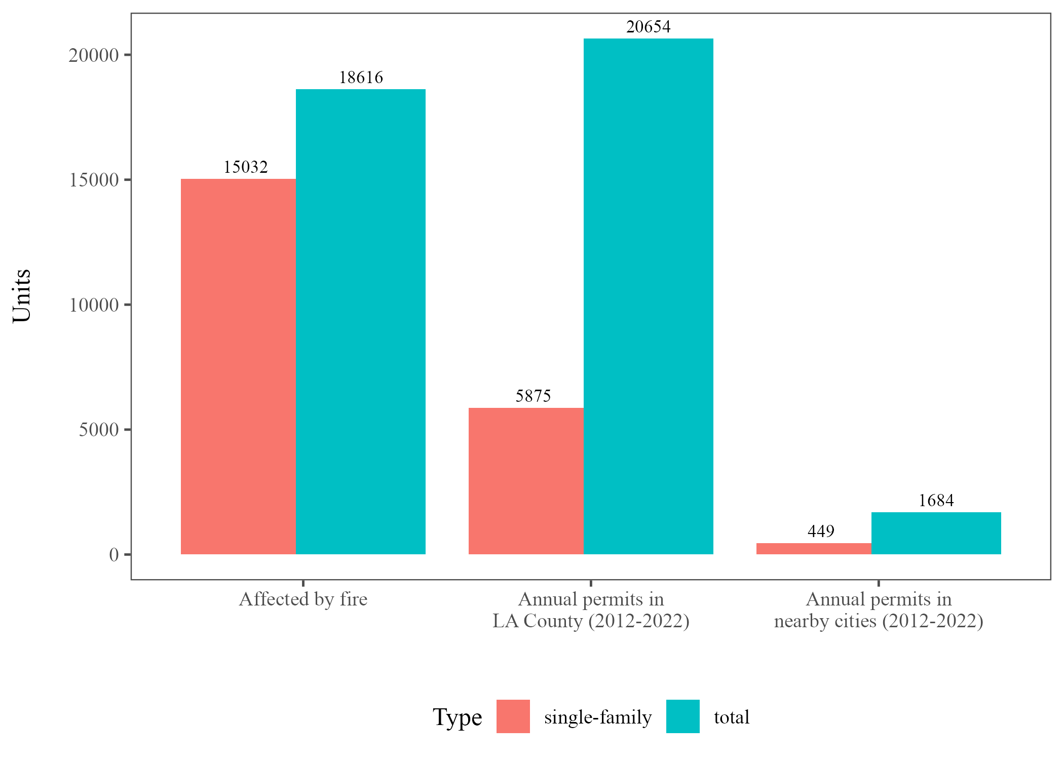
Consistent with the suburban character of both areas, the figures clearly show that single-family homes are the primary property type impacted by both fires. A detailed breakdown, displayed in the figures below, reveals that more than 78% of residential properties within the perimeter of the Palisades Fire are single-family homes. This share is even higher for the Eaton Fire, where nearly 84% of residential properties within the perimeter are single-family homes. Overall, based on our estimates, the perimeters of the two fires combined encompass 15,032 single-family homes and 18,616 residential structures in total, including condos, multi-family buildings, and duplexes.


The estimates above highlight the astonishing scale of this crisis. They also raise critical questions about how the housing markets in Los Angeles County will respond to the supply and demand imbalances created by the large number of potentially displaced households.
Los Angeles County is a massive urban area with a population exceeding 9.6 million. However, significant challenges limit its ability to absorb this shock.
In the medium and long term, the key challenge lies in the ability to adjust housing supply by rebuilding destroyed homes or increasing supply in other areas. However, despite a more than 150% increase in house prices since 2012, the construction of new housing units has been severely limited across the county. This is due to both geographic and regulatory factors, which complicate efforts to produce new housing supply.
The figure below illustrates how this is relevant with respect to the effects of the fires. On the left, we show the combined total number of structures within the perimeters, affected to varying degrees by the fires. As mentioned earlier, these are 15,032 single-family homes and 18,616 residential structures in total. Using data on new construction permits from HUD, we find that in Los Angeles County, on average, between 2012 and 2022, only 5,875 new single-family homes were permitted annually. This accounts for just 39% of the single-family homes impacted by the fires. When considering all residential structures, the total number of permits per year raises to 20,654. However, the number of structures impacted by the Palisades and Eaton Fires is alarmingly close to the total number of structures permitted in the entire county in a year.
When we restrict our analysis to permits issued in the cities near the affected areas (Glendale, Pasadena, Arcadia, Sierra Madre, Monrovia, Santa Monica, Malibu, Beverly Hills, West Hollywood, and Manhattan Beach), the number of housing units destroyed by the fire far exceeds annual new housing construction. Between 2012 and 2022, these cities combined permitted just 449 new single-family homes and 1,684 new residential structures per year.
Of course, part of the reason new housing construction has been so limited in the county is the scarcity of available land. In principle, this is not a constraint in the areas affected by the fire, where homes can be rebuilt on the same land. However, the figures above show that housing production in the county needs to step up substantially in order to meet this new need quickly.
The situation may be even worse if residents impacted by the fires choose to relocate to nearby cities in order to reduce their exposure to future fire risk. If this is the case, given the historically low levels of new housing construction displayed above, it may not be possible to adjust the housing supply in the new destination cities to accommodate the increase in demand. This would then trigger large price increases.
Overall, the fires may result either in substantial house price increases in certain areas of the county or in the relocation of households from the affected areas to locations outside the county.
Even in the short term, a crucial issue is the hot rental market in the county. Many displaced residents will have to temporarily relocate to rental units while basic services are restored to the affected areas and houses are rebuilt. Although the county has lost approximately 4% of its population since 2020,[1] rents for new listings have increased from 2020 to 2023 by around 15%, as shown in a recent study. The Zillow Observed Rent Index shows that the median monthly rent for the county is above $2,800. Either due to the sudden increase in demand or to potential price-gauging, rents could rise even further in the immediate aftermath of the disaster. As a result, even temporary relocation is likely to be extremely burdensome for affected households and may result in increases in housing costs across the county.
[1] Cities located close to the fire perimeters (e.g., Pasadena, Arcadia, and Glendale for the Eaton fire, and Santa Monica for the Palisades fire) have experienced similar decreases in population, ranging from 3% to 4.5%.